Sunday, December 13, 2015

La forêt de Thy

Distance: 13.8 km.  Elevation low/high/total: 18/248/646 m.
Difficulty:5.8/10.  Scenic: 9.1/10

A hike into an area that is generally avoided.  But the payoff - a fantastic "baignade" made it worthwhile.  Click pic for album, the geotrack is here

First hike in a month and a very nice one.  the region is not one that is often hiked apparently.  But we had an uneventful time and ended up at a baignade (swimming hole) that appears to have been in use since the early 1900s, likely established a "resort" area for mining crew.   (Note added after some research: The spot is apparently called the "Grosses Gouttes" and we found a written record of Scouts visiting there in 1935, but no discussion of who built the place.  We also got more confirmation that this is a dangerous place to visit given tension with the nearby tribes). There are steps and concrete sitting area built into the hillside lining one side of the natural pool.  No one else was there except us and a sizable number of very hungry fish.  The hike is relatively flat; the flora is as diverse and interesting as anywhere I've seen on the island.  We saw giant taro,a bamboo forest, picked and ate wild raspberries and even passed through a birch tree grove.  Definitely worth a return visit.


Sunday, November 15, 2015

Riviere We Puci

Distance: 5.8 km.  Elevation low/high/total: 105/135/103 m.
Difficulty:3.6/10.  Scenic: 7.3/10
A solo hike this time, in the vicinity of the Pont des Japonais.  This river (We Puci) is better than the one crossed by the Pont (Pirogues).  Click pic for photo album, the geotrack is here.
Just needed to get out for a simple hike so decided to return to the region near the Pont des Japonais.  I'd identified a different access point from which I could hike along the Riviere des Pirogues to return to the great swimming hole near the Pont du Japanais we'd found last year.  But ultimately I failed at finding the entrance track.  Instead, I found a different track and just 4-wheel drove towards the river, which turned out to to be the Riviere We Puci,  until I didn't feel safe driving further.  But I was able to get within a 100 meters of the river so it was grand.  Two swimming holes provided welcome relief from the rather warm conditions and next time I'll explore further upstream.  The trail is narrow at times and long pants, or at least protection for the shins is suggested.  Besides the vistas, there are still lots of old RR track beams and crumblingcreek-crossing wooden bridges and even an old RR car all along the trail.


Sunday, November 1, 2015

Vallee N'Go

Distance: 11.5 km.  Elevation low/high/total: 75/453/586 m.
Difficulty: 5.1/10.  Scenic: 5.2/10
An easy 11.5 km stroll.  Click on picture to view album.The geotrack can be downloaded here. A slightly longer track, showing the access road to hike start is here.
After a lengthy much-needed vacation off the rock, I returned and easily convinced Paul to accompany me on another hike.  We knew this one would be relatively easy but ... but it was still great to get out on this lovely day. Before setting out, we did a bit of four wheel driving in Frog and some exploration around the tree farm behind which this walk started.

We made the hike a bit more interesting than would happen by sticking to the main track ... which is essentially comprised of various old mining access roads, in various states of disrepair.  We hiked up one of the early hills tot he nearby windmill farm and found a great set of views and worked up a sweat.  Afterwards, it was all downhill to we finally recrossed the N'Go river which we first saw where we left Frog.

Saturday, October 3, 2015

La Couvelee

Distance: 7.5 km.  Elevation low/high/total: 53/267/495 m.
Difficulty: 7.0/10.  Scenic: 6.9/10
An "upside down" hike compared to usual in that we parked up the mountain and bushwhacked down to a river.  Click the pic for a photo album and the geotrack is here.  A more complete geotrack with the route to the top of the hang gliding take off location is here.
The next river valley over from Dumbea is called La Couvelee.  That there is a hike there is not well advertised.  Nevertheless, we tracked it down and Paul and I set off for our more-or-less-regular bi-monthly hike.  the day was not promising, weather-wise, so we diverted from the start of our hike to explore the nearby mountain top which is an authorized hang gliding take off location, complete with specialized track and wind sock.  The drive up there was a bit dicey, but then that's why I got a Land Rover.  Need to upgrade my tires though, some of the slipping and sliding along the rain-coated cliff edge road was a bit panic inducing.  Up at the summit, the weather whistled by and we enjoyed the mist and drizzle.  

The hike itself started a bit further down the mountain and was unusual in that we started off hiking down the mountain, literally bushwhacking our way for a about a kilometer through dense brush and trees with nary a trail to follow.  The geotrack shows how different our return route, bushwhacking uphill, was from the downhill part.  In all, not a long hike but our legs got pretty beat up and it was exhausting enough fighting uphill at the end of the hike that we feel we got in a full day's worth.  And the swimming down at the river was sa-weet!

Friday, September 25, 2015

Chutes de la Madeleine - Sentier Botanique

Distance: 3.5 km.  Elevation low/high/total: 238/259/37 m.
Difficulty: 1.6/10.  Scenic: 8.9/10
A short but fun and scenic hike to a waterfall and a botanical stroll.  Click pic for album, gpx file is here.
It's New Caledonia Day weekend so we had a couple of extra days off.  With the choice of either an extra French lesson or a hike with the 'rents, Iris chose the hike.  We chose a relatively easy one and one that we attempted once before but got rained out.  While the weather threatened initially, it turned out to be beautiful. So we drove to the Netcha area and walked to the Madeleine waterfall (Chutes de la Madeleine) and strolled along the Botanical Path (Sentier Botanique).  Just lovely and peaceful.  Highly recommended as a hike with kids.  While it costs (400 XPF), that also gets you admission to Netcha which has a lovely swimming area a few km away, though we opted to skip that as it's not quite swimming weather yet so early in the spring as it is.

Saturday, August 29, 2015

Yate Dam - Chemin des Dalmates

Distance: 19.1 km.  Elevation low/high/total: 15/372/481 m.
Difficulty: 7.2/10.  Scenic: 6.1/10


One of our longer day hikes, quite varied: from brutal bushwhacking through razor grass to refreshing rain forest to a stroll along a paved road.  Pics linked above, gpx here or via track below


We wanted to change things up from the crushingly vertical nature of the previous hike (Tour des Sommets).  So after scouting about a bit, found this lengthy but seemingly relaxed hike and, after a 90 minute drive from Noumea, Paul and I got on the trail by 9 AM.  And finally back off the trail about 8.5 hours later.  This one is varied - the first 9 km are easy-peasy, as you stroll along an old access road of some kind, then along an actual real road.  But then you get into the fun.  5+ km of essentially no marked trail and the entire way is knee high razor grass and short trees with stiff branches.  I made the mistake of wearing shorts - thought of uploading a photo of my bloody shredded shins but we're keeping this family friendly.

The hike follows the riverbed of the now deceased Yate River which gave up the ghost so that artificial Lake Yate could have life ... curiously beginning about the time that both Paul and I began life .... let's just say 50+ years ago.  the section nearest the dam is fascinating - old riverbed littered with boulders that apparently get moved around every so often when they have vent the Lake due to excess water buildup.  The rest of the time it's mostly dry (save for the occasional rainstorm runoff from nearby mountains downstream of the dam).  We were in the area at high tide and a surprisingly lengthy section fills up with seawater.  At the end of the hike we were greeted with a near full moon so this was a day of a higher than usual high tide.  The final 5 km of the hike are actually really pleasant "normal" hiking through forest with soft earth underneath, birds chirping and no sharp rocks/slippery mud/unfordable rivers etc.  All in all, an OK hike and one I'd do again (though wearing long pants).

Saturday, August 15, 2015

Tour des Sommets

Distance: 7.2 km.  Elevation low/high/total: 455/1054/766 m.
Difficulty: 9.4/10.  Scenic: 9.6/10
Sweet mama, this one is a workout!  Two of the taller peaks near Noumea and tough vertical scrambles both up and down.  Click pic for photo album and the gpx file is here.

This is a fairly brutal hike (at least for a couple of old mountain goats like us)!  But eight hours of persistence paid off and we are able to put this one in the books (or blog, nowadays).  Most folks, I believe, hike this route in a counter-clockwise direction.  One parks at the Auberge de Koghi, strolls to the waterfall and then climbs the very (VERY!) steep path to the top of Mount Mone and continue.  We went the other direction.  I think it was the right move, but either way is very tough.

Our route up was to climb My Bouo first and that route is very technical - involving mostly sharp rock navigating - much of it under rainforest cover so the rocks are covered with moss and very slippery.  The possibility of twisting an ankle or taking fall and having a very nasty landing is very real.  It took us 3.5 hours to scale the first peak.  But aside from numerous cuts and bruises, we made it and FTF'ed a geocache there.  Next, you hike/scramble the saddle over to the taller peak Mt Mone.  The view from both peaks and at many lcations all along the "hike" are quite spectacular.  We had lunch at Mt. Mone and then faced the daunting task of getting down off that peak.  Measured by our geotrack the slope exceeds 45 degrees for the better part of a full kilometer and the surface is slippery red mud with sharp embedded rock.  We did most of it sliding on our butts (my hiking shorts got destroyed).  Fortunately, I brought gloves else my hands would be shredded.  

This is a worthy hike but not one I'm likely to repeat soon given how truly dangerous it is.  It's not really hiking, it's rock climbing.  The views are great .... but so are they at several of the other peaks nearby which are much less technically challenging.  But ... we made it and now look forward to our next challenge in  a couple of weeks.

Sunday, August 2, 2015

la forêt Desmazures

Distance: 10.3 km.  Elevation low/high/total: 166/458/638 m.
Difficulty: 8.4/10.  Scenic: 6.1/10
A solo hike deep into a rain forest, generally with no visible path and only surveyor tape flags tied to branches as a guide.  Speaking of guides, a "real" French one gave me grief for hiking alone (made my day!). Click pic for Picture album.  GPX file here.

A beautiful, sunny, spring-like New Caledonia day practically yells for a good hike.  With my usual hiking pals all busy (or out of the country), I was left with the solo hike option, which is usually fine with me.  I scouted out an obscure hike not too far from Noumea and managed to identify one using a combination of OpenStreetMap and another local hiking blog.  The drive was only about 45 minutes out of town, but rather surprisingly I found nearly a half dozen vehicles parked at the trail head. a real novelty in my hiking experience here.

This is a difficult hike that is given less than a 9.0 only because of its relative brevity (4 hours, 10 km).  But the trail is essentially unmarked (save for surveyor tape) in many areas and the terrain is quite treacherous and dense in several areas. I made several wrong forays that probably earned me an extra km and half hour of hiking.  As much of the hike is rain forest, it was naturally raining most of the time despite the glorious sunshine that I could occasionally see in the distance over the ocean.

The main highlight of the hike are two pretty rivers that one crosses in the midst of the forest.  The first is about 5 km in and I had lunch there and cooled my feet.  I'd seen no one to that point; but at the second river (~ 7.7 km point) there was a crowd of about 15 people having lunch and soaking in river pools.  Turned out to be the group whose cars were parked at the trailhead.  It was a bit challenging to see where the path continued so I asked someone and they pointed me to their guide, a cranky old French guy.  I got within 5 meters of the guy and he just lit into me about how irresponsible and stupid I was to be hiking in this area on my own, yadda, yadda, yadda.  I smiled, thanked him (which only seemed to further infuriate him) and asked him which way the trail continued.  He would not tell me nor even look at my GPS, but a kinder English-speaking guy in the group said that he was pretty sure it continued across the river a bit further along.  Which it did.  Ah, the French being French; definitely added a bit of pep to my step the remainder of the hike.

There are several branch trails off the path I took so I think I'll be back to explore those (likely without a pricey, judgmental French guide).  Placed a geocache (linked here), got back to my vehicle without incident and returned in time to enjoy an ice cream treat with the family back in sunny Noumea.

Wednesday, July 8, 2015

Col du Ga Wivael/Roches de Linderalique

Distance: 9.3 km.  Elevation low/high/total: 12/283/628 m.
Difficulty: 7.7/10.  Scenic: 9.3/10
A "real" hike and one that could have been spectacular (had it been sunny).  Click the "Brooding Hen" (Poule Couveuse en francais) for pics; geotrack here.
There are two hikes in this region and, as they join at one point, I did both of them thus making two 7 km hikes into a single 10 kmm hike with a good amount of elevation change.  The views from the two peaks are spectacular, though less impressive against a cloudy sky.  These hikes are above the town of Hienghene and the rock formations are known as the Sphynx and the Brooding Hen.  The black limestone Roches de Linderalique are also fabulous - and I camped one evening near the base of the limestone rocks.  Great hike.

Monday, July 6, 2015

Sentier de Marais Sainat

Distance: 3.07 km.  Elevation low/high/total: 11/46/82 m.
Difficulty: 3.0/10.  Scenic: 6.5/10 (it was foggy)
A simple stroll, it's significance is that it's located at the far northern extreme of "Grande Terre", the main island of New Caledonia - a spot not often visited by tourists.  Pics by clicking above, geotrack here.
The first of just two hikes I could do on my walkabout (the caves didn't really count as a hike) but this was nice given its location.  I loved the signs explaining how the Kanaks view nature and the resident animals.  Had a nice picnic during a drizzle break.  Would love to return when the sky was blue.  And also to tear down the stupid cell phone tower that's erected at essentially the northernmost point of Grand Terre.

Grottes de Koumac (Caves of Koumac)

Distance: ~ 700 m.  Elevation low/high/total: 15/15/0 m.
Difficulty: 8.5/10 (scary/bats).  Scenic: 1.0/10 (pitch black)
Not so much a hike a as a dare, I explored these caves despite the dire warning not to do so by myself.  Small set of pictures can be seen by clicking above, location of cave area here.
This is a bit of fun.  If you like dark places, filled with bats, and the potential for being "gassed".  Took me three tries to find the right way in and then I got lost (thanks, random punks that paint "wrong way out" arrows all over the place) briefly before finally finding an exit about 80m from where I entered.  Can't wait to show this place to Ildiko.

Sunday, July 5, 2015

On the road to the Northern Province

Distance: ~1500 km.  Elevation low/high/total: 0/588/5610 m.
Difficulty: 7.8/10.  Scenic: 9.1/10
Everyone else had enjoyed a nice vacation recently but it had been nearly a year since i got away so ... I got away. Picture album by clicking on the Frog above, geotrack here
I've been living in New Caledonia for about 16 months now.  And, while I've done a goodly amount of hiking and exploring, the northern half of this country - of Grand Terre - was Terra Incognito (Unexplored) to me.  So I carved out a week, prepped the Land Rover ("Frog"), gathered my camping gear, did some research and early on a July 2015 Sunday morning set out for parts unknown.

The trip was great and just what the doctor ordered.  I saw new things, went places few have ever been and got to camp out for a week, an activity I love.  That all said, man ... the freakin' rain ... basically 5 of 7 days I had to take shelter from the storm(s).  Thus my pictures are mostly gray.  That hardly mattered when I was cave explorin' but it seriously cut down on hikin'/fishin'/beachcombin'.

I took five cameras (three dedicated, 2 on cell phones) and amazingly they all survived.  Maybe next year I can rally a couple of fellow explorers and we can check out places I never got to, or would like to see again.

I managed three hikes on the trip:

Les Grottes de Koumac (Caves of Koumac)
Sentier de Marais Sainat
Col de Wivaek/Roches de Linderalique


Sunday, June 14, 2015

Hiking the GR1 - Stages 4 and 5

Distance: 30.1 km.  Elevation low/high/total: 155/532/1181 m.
Difficulty: 9.1/10.  Scenic: 7.8/10
And so we finished off the GR1 with a two day 30 km hike through the western end of the Parc de la Riviere Blue.
Click picture for photo album, the geotrack is here.

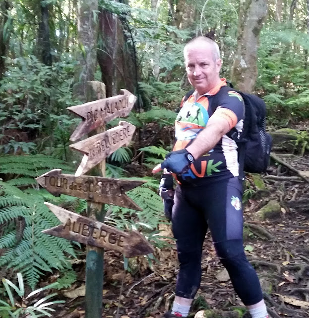
And now the GR1 full traverse has been accomplished.  My daughter, Kincso, and I (and, on various Stages accompaniment from Ildiko, Paul and Simon) made several treks over many months to hike the length of the hugely impressive GR1 put together by the tourism/park folks here in New Caledonia.  And, while we did hike it from beginning to end, we shortcutted the middle section as Stage 4B is an abbreviated section connecting Stages 3 and 6.  This weekend, my friend Paul and I completed the "skipped" sections, i.e., Stages 4 and 5.  We had hiked the six other sections in the generally intended direction, from east to west.  For logistical reasons (and doing the GR1 requires a LOT of logistical planning), we decided to start our hike at the "end" of Stage 5 and hike west to east, finishing at the "start" of Stage 4.  Because of the remoteness of the endpoints, much like Stages 6 and 7, we decided to do the two stages back to back and overnight at the Refuge offered between Stages 4 and 5.  

Weather, always an issue up in the mountains across this part of New Caledonia, could have been better but at least we didn't deal with a Category 1 cyclone like the last time we did a back-to-back stretch (Stages 6 and 7).  We set out in a light rain and ended in a light rain, but the rivers and creeks were fairly easily traversed and these two stages presented much like the other stages within the Parc de la Riviere Bleu.  The only real downside was that we were both breaking in new hiking boots and we had some serious foot blister issues the last half of day 2.  As on all the other Stages, we placed geocaches along each, bring the total placed along the length of GR1 to 10 (at the beginning, Stage 1, Stage 2, Stage 3, Stage 4, Stage 4B, Stage 5, Stage 6, Stage 7, at the end).

A couple of final comments about this amazing outdoor resource provided for the public by the tourism bureau here.  The 130+ km trail has been meticulously cared for - from paths carved through almost impenetrable rain forest to steps built into steep slippery slopes to a multitude of constant signage pointing the way to go (and not to go).  The refuges provided in between stages (we used two of them - at Camp des Fougeres and Tristaniopsis) are extremely well built and provisioned.  At our stay at Tristaniopsis on this hike, we arrived to find a well stocked woodpile and kindling! and the shelters themselves are solid and watertight.  Somewhat puzzlingly, and sadly, on all our hikes we encountered only one other hiking group!  Whether this is a failure of advertising or a matter of indifference I can't say but on the plus side - O! the solitude!

When told of our completion, Ildiko asked so ... what's next?  Hmm, I have read that a companion set of hikes is nearly completed in the northern part of the island ....

Sunday, May 24, 2015

Marmites du Diable (Devil's Cauldrons)

A scenic and relatively easy hike along a river of crystal clear water to a set of swimming holes.
Click picture to see a photo album.  The geotrack is here.
A lovely Sunday morning and Paul and I got out on the path relatively early.  Our hike today was along the north branch of the Dumbea river; we'd crossed and hiked much of the south branch several times in the past so it was time to "branch" out.

The hike is mostly flat, gaining barely 100m of altitude and the round trip to the Marmites is 12 km.  We saw more people, including two large groups of at least 20 people, on this hike than on all our other hikes combined.  Folks were "hiking" in flip flops and carrying coolers.  The highlight for most are the Marmites, or Pots (Cauldrons) which are deep swimming holes at certain stages of the river.  The river seems to flow through a canyon in several places.  At one spot, pictured above, there's a jumping off spot about 10-12 m above the water.

Paul and I went another km or so past the deep pools and found a more rewarding stretch of smaller pools, where the water is almost impossibly clear.  We enjoyed a swim, alternately in the rain and sun, then had a picnic lunch and set on our way back.  Of course, we placed a geocache to mark the outing.  A highly recommended hike, and one great for kids or those not fond of uphill hiking.


Thursday, May 14, 2015

Ruisseau des Kaoris hike with Ildiko

The sign on THIS side of the crossing to the thermal springs.  Click pic for photo album. 
Geotrack of 10 km round trip hike is here.
On a sunny mid week work holiday, Ildiko and I set off on a pleasant hike.  Iris was having a playdate with a friend so it was just the two of us.  The drive to the hike spot is nearly two hours and is about 20 minutes past the turnoff to the old abandoned slave labor camp of Prony.  The hike starts at about 150 m of altitude and descends early on to be a flight hike for most of the time. However, it is slippery red mud on the way down - but we maintained our balance.  To get to the hot springs, you have to eventually cross a fairly wide river delta (which can be a lot wider after heavy rains). We considered our options and finally decided to cross the river rather than retreat out to the bay (as Jim G and I did back in February after a heavy rain storm).  No option but to wade in and deal with wet shoes/socks from then onwards.

Upon arrival at the hot springs, we found some trustafarians had set up camp obviously having been there awhile already but were polite enough to retreat for a spell so we could enjoy the warm pool.  the pool was not warm and, in fact, was a bit cool but having come this far, we had to take the plunge.  A nice lunch was had and we turned our sights upon the return and made it back a bit quicker than we had come.  This hike likely spells the end of hikes in the southern part of New Caledonia for awhile as we've done most of the listed hikes.  

Sunday, May 10, 2015

Piste du Mont Poudehoume

Distance: 13.0 km.  Elevation low/high/total: 18/609/763 m.
Difficulty: 5.5/10.  Scenic: 6.5/10
Paul and I set out for a relatively easy Mother's Day hike out behind Dumbea
13 km hike over 5 hours, about 750 m elevation gain.  Click pic for album, geotracks are here: gpxkml
Well, the hiking daughter has left for other adventures, yet I hike on.  I got my friend, and frequent hiking partner, Paul to join me on a Mother's Day jaunt up a mountain ridge behind the village of Dumbea, where he lives.

What he advertised as a quick three hour jaunt .... he didn't even pack a lunch ... turned into a 5+ hour good workout.  I kinda sensed this would be somewhat more involved than he opined, so fortunately we were able to enjoy a fine lunch of cheeses, ham and local veggies mid route.

The last half of the hike tied into the end of the GR1 (Stage 7), which we had completed a month ago with Kincso, at the tail end of Category 1 Tropical Cyclone Solo.  Conditions could not have been more different this time.  Blue skies, moderate temperatures, and not-so-slippery paths were the operating norms today.  We placed one final geocache to commemorate the end of the GR1 (linked here)  and now plan on something a bit more challenging next weekend.

Sunday, April 26, 2015

Hiking the GR1 - Stage 4B (Abbreviated Stages 4/5)

Distance: 13.9 km.  Elevation low/high/total: 155/206/352 m.
Difficulty: 4.5/10.  Scenic: 4.5/10
https://plus.google.com/photos/117025454240573054599/albums/6142530982415979825
Filling in the missing segment, we completed our quest to hike the length of the GR1.  This particular segment, admittedly the easiest and serving as our GR1 coda, was 14 km long. 
Click pic for photo album. The geotrack for the hike is here: (gpx) (kml)

We did it!  Five different outings, some wild experiences, nearly 100 km total trekking through all manner of mountain/mud/brush/river/desert and Kincso and I can say that we have hiked the length of the Grande Randonée Nouvelle Calédonie 1 (GR NC1, usually just abbreviated as the GR1).  This particular section, Stage 4B, is the missing link between the end of Stage 3, which we completed at the beginning of April and Stages 6/7 which we completed during Tropical Cyclone Solo a couple of weeks ago.  Stage 4B is actually a shortcut for Stages 4 and 5 but time was running out and those shall await another time.

For this particular stage, we were joined by Ildiko and my friend Paul, with whom we've done a few other hikes.  Technically, this is the simplest of the Stages as most of it takes place along a level red dirt road.  The high hope we had was to see, in the wild, the national bird and symbol of New Caledonia - a Cagou, as seen above.  And we did!  We even got to spend some time close enough to one that it was hissing at us, a noise I had trouble believing at first could be made by such a beautiful bird.  We also placed, as we did on every Stage, a geocache along the way (linked here).  As of today, NONE of the caches has yet been found/logged - likely the result of so little trail traffic, as discussed below.

A couple of final comments on hiking this quite impressive trail.  The GR1 presents one with a nicely varied set of experiences.  The length and vertical range present varying levels of challenge and I would rate the whole thing as quite difficult.  The trail is very well maintained and marked, with one notable exception: there needs to be more distance markers.  Most stages are only marked at the 1/4, 1/2 and 3/4 points but those are 4-6 km apart and it can be hours getting between them.  Many markers are placed all along the trail - to prevent getting lost - it would not be a chore to add a clip on distance marker at every 500 m point.  the other amazing thing we noticed was how utterly unoccupied we found the trail.  I think we passed one other set of hikers over the six stages we did.  Not sure why that is given the overall general healthy nature of folks here but a great deal of time and money went into creation of this national treasure and it seems a pity it's so underutilized.

Miss K (Kincso) heads off to Europe and then U Cal Berkeley in a couple of weeks, so I'll be losing a hiking buddy.  I think she gained a lot of self confidence and learned that persistence is one of her innate strengths - she's gonna be a great college student!  May these pages provide her with a reminder of time we spent together that will always rank among my favorite outdoor adventures.

Saturday, April 11, 2015

Hiking the GR1 - Stages 6 and 7

An epic misadventure spread across two days.  We hiked 30 km, gained 1700 m of altitude and battled the onslaught of Cyclone Solo to conquer Stages 6 and 7 of the GR1.  Click above for picture album.  Geotracks here: (gpx) (kmz)
Kincso has been accepted, and likely will attend, U Cal Berkeley in the fall.  She leaves New Caledonia in less than a month.  We still had four sections of the GR1 to complete.  This weekend was the one penciled in to complete the final two legs (we'll fill in the skipped legs later) and we had my friend Paul along for the adventure.  Due to the remoteness and difficulty of access, you really need to do these two legs consecutively with an overnight at one of the refuges high up in the mountains.  There was news of a forming tropical storm (which became Cyclone Solo) but we apparently misread when it would strike New Caledonia, thinking we had until Sunday evening before the rains would hit.  We were wrong about that.

Ildiko dropped Kincso and me at a meeting point where Paul, his wife and sister picked us up and we headed for the Parc de la Riviere Bleu.  Once there we drove to the furthest point - Pont Perignon - where a park ranger took us deeper into the park to the start of Stage 6.  We hiked about 8.5 hours on Day 1, mostly through thick rain forest and relentlessly uphill for the second half of the day.  Many rivers were crossed and we had some soakings and Kincso got a nasty cut crossing a particularly slippery set of rocks.  We didn't make it to the end of Stage 6 - which was 15+  km but there was a smaller shelter at the 13 km stage and we spent the night there.  The A frame huts proved to be a huge benefit because the rains arrived shortly after we got there.  There was just enough firewood to warm a sandwich and some chicken bouillon.  We were inside by 7 pm and out of the torrential rains that fell all night long.  Upon waking, the scene outside was surreal.  Standing water everywhere and steady heavy rain.  Nothing we had was dry.  

We faced the final 3.7 km of Stage 6 - all uphill - to get to the start of Stage 7, which itself was a 15 km hike mostly downhill back to Dumbea.  The effect of the rain on the paths, the footing, the rivers, the red mud roads at the end - words can't do it justice.  This was without a doubt the toughest two day hike I have ever done, and Paul and Kincso concur.  Kudos to Kincso for persevering, and learning what amazing inner strength she has - and to Paul who was a positive force and morale booster the whole time.  Our pictures (link to full album at picture above) may not have captured the surrealist aspect of the whole hike: we went to great lengths to protect our electronics from the biblical rains and simply could not risk taking them out at times.  But hopefully we captured enough to paint a picture.  These two stages of the GR1 are in another league relative to the other stages, and we are all thrilled to have finished them off, likely never to be repeated.

We did place two more geocaches as we've done for each leg (linked here and here).  The final kicker to the whole hike was that the good park folks CLOSED the car park access where Ildiko was to  pick us up, and so just when we thought the whole ordeal was over ... we had to hike two more km out the access road to get back to the closed gate, thus extending the Day 2 hike to a full 10 hours done completely in totally wet cold clothing and footwear.  Good times.  How soon can we complete the other legs?

Friday, April 3, 2015

Hiking the GR1 - Stage 3

Distance: 15.3 km.  Elevation low/high/total: 163/491/555 m.
Difficulty: 5.0/10.  Scenic: 5.0/10
We had Simon along as company on the 15.4 km Stage 3 hike
Click on the pic for link to picture album, geotrack links: (kml) (gpx).
Less than two weeks after completing Stage 2 of the GR1 (the Nouvelle Calédonie Grande Randonée 1, or GR NC1 as it's officially titled), Miss K and I were able to tackle Stage 3, thanks to the willing participation of an SPC colleague, Simon Nichol.  Heading out on an early Good Friday (hence, work vacation day) morning, we drove to the western terminus of the hike, which is near the eastern entrance to the Parc de la Rivière Bleu, dropped his truck there and then the three of us drove over to Netcha which is the eastern terminus of the hike.  We managed to hit the trail just after 9:30 AM on a semi overcast, quite pleasant day for hiking.

While the overall length of the hike suggested  it might be a bit of a challenge, in fact this was the easiest of the 3 stages to date.  The 15.4 km hike took about 4.5 hours and involved two relatively modest hills (well, one was modest) and provided some spectacular vistas.  We crossed a couple of creeks as well as a mostly dry riverbed that was littered with thousands of huge boulders indicating that, on occasion, some serious flooding (from a typhoon, perhaps) washes through the valley here.  We placed a geocache (linked here) at the top of Agathis Pass, where we also enjoyed a nice lunch.  Next up is Stage 4, which is inside Parc de la Rivière Bleu, and hopefully we'll tackle that shortly. 

Sunday, March 29, 2015

Depardieu and the wind turbines of Plum

Distance: 9.3 km.  Elevation low/high/total: 6/434/537 m.
Difficulty: 6.5/10.  Scenic: 8.5/10
A solo hike up above the village of Plum to visit their wind farm - click pic for album
The geotrack is linked here(gpx) and here(kml)
Once again I found myself without a hiking partner but my feet were so itchy I just had to get up and out.  Quite often, on my way down south, I pass the lovely little town of Plum - last village before you head into the mountains.  A string of wind turbines can be seen up on the plateau above the village and, turns out, there's a hiking trail to get up there.  So, up I went early on a hot Sunday morning.

My friend Paul later told me this trail was known as the "goat scramble" and it was tough going for awhile.  The trail is quite vertical in places and you haul yourself up hand over foot across sharp rock and brush.  As it's on the lee side of the mountain, the air is rather dead and I lost a lot of water weight (i.e., I sweated like a pig).  But the view up there was spectacular.  The best of all though was my meeting with an unexpected giraffe.  There he stood, proudly surveying the scene beyond the line of wind turbines.  I named him Depardieu because, well .... French, big nose, stoic, gerard le giraffe ... seemed a natural name.  I placed a geocache at his feet (linked here), and then headed back.  There's not really a trail to follow heading back till you're about half way down and can then follow the power lines.  The descent was even trickier in places - loose stones, slippery dirt, the usual.  It was, all in all, a lovely way to spend a weekend day.

ps - I'm in the market for a hiking buddy, as my usual companion is about to leave New Caledonia and start college at Berkeley in a few weeks.